
We have been witnessing a massive uptake in 3D spatial information and virtual reality presentation of this information. The next couple of years are going to be very interesting, considering the up and coming consumer launches. Below is my take on the coming revolution in scanning 3D - a version of this post was first published in Lidar News.
--
A few weeks ago it was announced that Google and Lenovo will start deliveries of the Phab 2 Pro Smartphone, the first Tango enabled device on the market. The developer kits, which have been on the market for some time now, are specified with a suite of sensors covering a motion tracking camera, 3D depth sensing, acceleration, ambient light, barometer, compass, A-GPS and gyroscope. Apparently the same set of sensors are to be integrated into the Phab 2 Pro.
Now this is a very impressive data capture device, without even looking at the detailed specifications of the depth sensing or resolution of motion sensors. We already know the actual performance of other sensors, like the Microsoft Kinect (the original Primesense technology, acquired by Apple in 2012 for $345 million), and it is clear that a 16MP camera, like the one on the Phab 2 Pro, can provide some seriously good imagery and video which can feed photogrammetry algorithms to produce very high quality 3D data and pointclouds. Do you want to speculate what the next generation of iPhones will be looking like? I would look no further than the project Tango devices.
On the market today, we can find devices like the Dot Product LLC DPI-8, essentially an Android tablet with a Kinect like sensor with some very innovative software, or the GeoSlam Zeb-1and Zeb-Revo, a handheld scanner based on Hokoyu’s UTM-30 series of scanners were originally designed for automated robotics use. High precision and performance structured light sensors are widely available for industrial metrology applications. All these devices capable of capturing relatively close 3D typically sell for at least $2000 upwards, with the sky being the limit for extreme accuracy.
Intel has launched a complete range of RealSense 3D sensors which are starting to become available on all types of devices, including laptops, phones and even a commercially available UAV from Yuneec Electrec Avaition, which received a $60m investment from Intel in 2015. Now these are not yet high performance measuring devices, but we can all see the trends.
More interesting is what we see emerging for home and desktop use. Recently on Indegogo, a campaign was launched by eora 3D of Sydney, Australia, for a $289 desktop scanner that is driven by iOS or Android devices, which is claimed to deliver performance of “an unprecedented sub-100 micron precision, feature size: > 500 microns, Scans are captured in full color and rendered in-app on screen, scan up to a range of 1 meter (3 feet).
Based on a typical smartphone camera’s Field Of View this lets you capture an incredible 1 square meter (3 feet X 3 feet) in a single scan. For objects that are larger, you can take multiple scans and stitch them in-app or on compatible desktop software.” There are also a plethora of web based apps which will allow you to use your existing smartphone to capture 3D content by simply taking multiple images or video, which is then stitched together, but many of the accuracy claims should be carefully considered and tested before thinking about these as serious tools.
The point I am making is that I believe that we are on the cusp of an entirely revolutionary period, which will have dramatic ramifications on the 3D scanners dominant in the past 15 years. The companies manufacturing these are seeing sales leveling off and even declining, indicating a very maturing market. These extremely low cost portable and simple devices will drive new software methods which will map the entire world, both exteriors and interiors. We already see an emergence of crowd sourced indoor location and navigation services. Combine these with accurate affordable sensors in public hands and quickly, through iterative data comparison and alignment, high accuracy models can emerge.
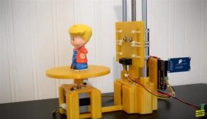
Going back to 2005, when I was involved directly in Optech’s corporate management of 3D scanning product development, manufacturing and sales, I was approached by a group of York University students who had to do a 4th year project, headed up by a very sharp young man named Marwan Hussein. Their interest was to build a 3D scanner, but really had no idea how these devices worked. I coached them with some fundamentals about the differences between time-of-flight, phase shift and 3D triangulation range measurements. They had a budget of $1000, and 8 months in which to complete a demonstration. With almost no further interaction, I received a call at the 8 month period where the team wanted to demonstrate what they had achieved. I was absolutely astounded that they not only built functioning desktop 3D scanner, but also had written a scanner control, point-cloud capture and display software. They even made a mock-up catalogue (this link will automatically scroll you through 3 pages at 4 second intervals! Marwan and some of the team went on to become part time employees of mine, while Marwan continued with a career in our development team, following which he extended his education at MIT, and currently is working for Apple in the San Francisco Bay area.
Looking back on that project, it was extraordinary to see the results of a student project back then with such a limited budget, and the products that are now emerging in the latest technology rollouts. Of course there are great advances in the integrated sensor development that are enabling dramatic cost and performance reductions, but the underlying concepts are the same.
--
About the Author
Brent Gelhar is a technology commercialization consultant based in Toronto, Canada. He has been involved in development and market rollout of static 3D scanners, mobile mapping systems and a wide variety airborne lidar systems while working at Optech Inc. He currently is working with a variety of high technology startups, providing guidance to funding and market entry. Learn more at his website www.spatialinitiatives.org and his LinkedIn profile.
--
Like this content, but want more? Management Consulting Week 2016 is coming to Toronto this fall! Head on over to CMCweek2016.com to get the details on all the great speakers and planned activities.